Descend To What Altitude?
- July
- 13
- 2017
- Advanced Aircrew Academy
During a recent descent, I was faced with a difficult decision about what altitude I was supposed to descend to.
I had been cleared to "DESCEND VIA" the ANTHM3 RNAV into KBWI. As you can see from the image, the lowest altitude listed for landing to the east is 4000' MSL, and I had 4000 in the FMS and Flight Control Unit as we descended through FL180 to meet all the crossing restrictions.
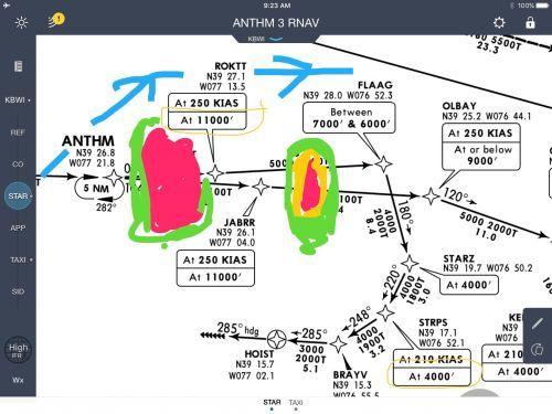
There were some pretty severe storms in the area and the image shows (don't laugh at my crude colors) a cell between ANTHM and ROKTT and FLAAG. ATC was doing a good job getting everyone around the storms and still getting in on the approach into BWI, but they were swamped with calls for diversions.
I asked for a vector to the north (the blue line) and the controller cleared me for 20 degrees left, but he neglected to give me an altitude to descend to in the madness that is the morning crush on the East Coast. You know how the radios seem to get that static interference at just the wrong time? Yep, that happened to me. All I heard was static, and attempts to contact ATC either did not go through or we could not hear a response.
I was on a vector, with no way to contact ATC until we were through the weather, and not sure what altitude we were supposed to descend to. I honestly didn't know what altitude to descend to, but I reverted to some basic instrument rules and thought that I was at least cleared down to 4000' because that is the "bottom" of the STAR. The problem as I saw it was: When could I descend to that altitude, because we were not on a published segment of the arrival? The TCAS had airplanes EVERYWHERE and the last thing I wanted to do was cause a bunch of TA/RAs because I came barreling down to 4000'.
I still had the arrival displayed in the FMS and we were sort of paralleling it to the north. I used the altitudes displayed for the points we were abeam and just made sure I didn't go any lower than that until we were past the waypoint.
Just past FLAAG, we were able to hear ATC and got vectored to the south with a descent altitude of 3000'. The controller never said a word about our altitude.
What would you have done?
