NAT RLatSM Briefing 2
- November
- 11
- 2015
- Advanced Aircrew Academy
Last month in our newsletter, we posted an article on the implementation of Reduced Lateral Separation Minimum (RLatSM) in the North Atlantic. This briefing summarizes the changes.
Advanced Aircrew Academy has an eLearning module available to cover the changes. The changes are detailed in NAT OPS Bulletin 2015 - 003. Crews should, at a minimum, review the bulletin.
On 12 NOV 2015, significant changes will occur to the design and structure of North Atlantic Tracks (NAT OTS), which have existed in their current lateral structure since the OTS introduction in 1965.
The key changes include a reduction in separation to 'half-track' compared to the existing structure, introduction of 24 new Oceanic Entry Points (OEPs), and some procedural changes. These changes affect all operators on the North Atlantic. The Shanwick and Gander OCAs and adjoining domestic airspace will be affected.
History
1956 Selcal introduced on HF
1961 First occasional use of NAT Tracks
1965 First publication of daily NAT Tracks
1966 Consolidation of Shannon and Prestwick centers to create 'Shanwick'
1977 MNPS Introduced
1981 Longitudinal separation reduced to 10 minutes
1996 GPS approved for navigation on NAT; OMEGA withdrawn
1997 RVSM introduced on the NAT
2006 CPDLC overtakes HF as primary communications method
2011 Longitudinal separation reduced to 5 minutes
2015 RLAT introduced
12 November 2015 Changes
- Officially designated as a Trial, but RLAT Tracks are available to all operators meeting the existing airspace requirements and the RLAT CNS (Com/Nav/Surveillance) requirements below. No need for application to any authority.
- Each day, for both east- and wesbound tracks, a new RLatSM Track will be inserted at half latitudes between two of the core tracks.
- The RLAT Track will have half-degree latitude separation with the two tracks beside it. In other words, it will be spaced 30nm from the tracks to the north and south of it.
- This has the effect of making three RLAT or RlatSM tracks (Reduced Lateral Separation Minimum).
- A series of new OEPs are introduced.
- The North American Route (NAR) structure is amended to match the new OEPs.
RLat Tracks
- RLAT Tracks will 'sit into' the existing track structure.
- RLAT Tracks are FL350 to FL390 only.
- Phase 2 of the Trial will extend the RLAT minima to all tracks between FL350-FL390, with an estimated implementation date of May 2016.
New Oceanic Entry Points
Gander OCA/Gander Domestic Boundary:
LIBOR, NIFTY, RADUN, TOXIT, VESMI, BOKTO, ENNSO, IRLOK, KODIK, MELDI, PELTU, SAXAN, UMESI, BUDAR, IBERG, MUSAK, OMSAT, RELIC.
Additional new waypoints for NAR Design:
MUSLO, SINGA, UDMAR, ALSOP, DUBVI
Scottish/Shanwick Boundary
OEPs in bold, landfall fix in brackets:
60.5N LUSEN (ELCOG)
59.5N ORTAV (ODPEX)
57.5N ETILO (EVNAL)
Best Oceanic Transition Area:
47.5N UMLER (UMOXA)
46.5N BUNAV (TIVLU)
You can download a plotting chart that shows these new waypoints from the Flight Service Bureau.
Aircraft Requirements
As the RLatSM Tracks will always be within MNPS airspace, operators must meet the existing basic MNPS requirements and the additional RLatSM requirements.
Any flight that meets the following requirements as filed in their ICAO flight plan can be routed or re-routed by ATC on an RLatSM track:
- be MNPS approved;
- be RNP4 approved;
- be ADS-C and CPDLC equipped and authorized; and
- have the required CNS systems operational.
ICAO Flight Plan
- Field 10a (Radio Communication, navigation and approach aid equipment and capability) – J5 for CPDLC FANS1/A SATCOM (Inmarsat), J7 for CPDLC FANS1/A SATCOM (Iridium) data link equipment
- Field 10b (Surveillance equipment and capabilities) – D1 for ADS-C with FANS 1/A capabilities
- Field 18 (Other Information) – PBN/L1 for RNP4
This means that simply including the appropriate codes in the ICAO flight plan makes a flight eligible for the routing. The documentation as currently worded could imply that, to be eligible, you must meet the requirements, and if you did not flight plan a RLatSM track, then you would NOT be routed onto a RLatSM track. This is not the case. If the codes appear in your ICAO flight plan, then they CAN route you onto an RLatSM track whether you filed the route or not.
Pilot Requirements
Logon to OCA Datalink 20 minutes prior OCA boundary unless already logged on to adjacent ACC. The logon is required so that ATC can send a check message for the next waypoints. Failure to log on means RLatSM clearance will be cancelled.
Contingency Actions
There are no changes to the inflight contingency procedures and weather deviation procedures as detailed in PANS ATM Doc444 Para15.2 and 15.2.3.
SLOP procedures are also unchanged.
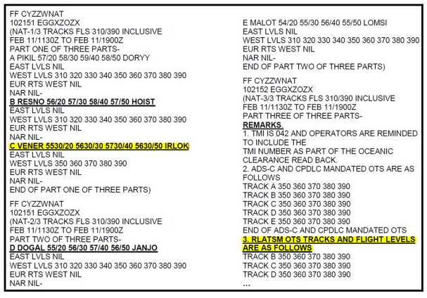
Track Message
As noted in the last briefing on RLatSM, as of 12 Nov 2015, the format of the NAT Track message will change slightly. Item 3 in the notes will list the letters of the RLatSM Tracks. An example of this format is below:
EMPHASIS – Error Checking
ARINC 424 coding format in the North Atlantic uses the position of the alpha character "N" to denote full-degree or half-degree of latitude. For half-degree of Latitude waypoints, an "N" prefix is used:
N5040 – leading character – half degree of latitude, i.e. 50 30 00N 040 00 00W
5040N – trailing character – full degree of latitude, i.e. 50 00 00N 040 00 00W
Incorrect placement of the “N” character (prefix vs. suffix) can, and has, led to gross navigation errors and reduced separation of aircraft.
Pilot Preflight and Inflight SOP must call for each pilot to independently display and verify the expanded DEGREES and MINUTES loaded into the Flight Management Computer (FMC) for each waypoint defining the cleared route of flight.
Due to operational difficulties in using the "N" prefix format that resulted in GNEs, effective September 17, 2015, Jeppesen began supplying third-party providers with a navigation database with the "H" prefix enabled (H5520 = N55°30' W020° 00').
Refer to the Jeppesen Nav-Data Bulletin: "Half Degree Grid Waypoints"
Reference Material
The following source documents have been combined for ease of reference and can be downloaded with the link below.
{phocadownload view=file|id=3|text=NAT Track Structure Changes|target=s}
- ICAO NAT Ops Bulletin 3-2015 – RLatSM Special Emphasis
- UK AIC 65/2015 – Introduction of RLatSM Trial
- NATS RLatSM FAQs
- Canada AIC 25/2015 – RLatSM Airspace Changes
- Canada AIC 26/2015 – RLatSM Trial
- Jeppesen Nav Data Bulletin – Half Degree Grid Waypoints
![]() Thank you to FSB for information provided for use in this briefing.
Thank you to FSB for information provided for use in this briefing.
